

UPDATED: Latest projections show Hurricane Lorenzo tracking over Louth

Lorenzo
Of interest to us is the latest GFS run which has changed again and now shows Lorenzo right over us at 8am Friday.
As national weather forecasters keep a close eye on the progress of Hurricane Lorenzo, the latest projections for Louth do not look good at present.
According to Louth Weather this evening, the latest projections for Thursday evening from The US National Hurricane Centre show Lorenzo coming "much closer to Ireland's western shores than earlier".
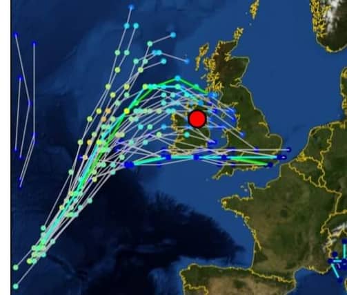
Worryingly for Louth, some projections even show the Hurricane arriving over the Wee County:
"The GEFS models are now showing it tracking towards Ireland's west coast and then taking a right turn with several of the tracks on the storm track spaghetti model showing it over Co Louth", explained Louth Weather.
The local weather expert added that there was still time for the projections to change though.
"Again please keep in mind what I keep saying about these predictions and expect further changes, but as the time period shortens we do expect the accuracy of the forecasts to increase. Stay tuned for further updates".